
How Modern Surveying Technology Is Transforming Construction Projects?
- Anjali Regmi
- Jun 9
- 7 min read

The construction industry has always depended on accurate measurements, precise planning, and reliable site information. Surveying, often considered the foundation of every construction project, plays a critical role in determining land boundaries, elevations, topography, and the exact positioning of structures. Traditionally, surveyors relied on chains, tapes, levels, theodolites, and manual calculations to gather data. While these methods served the industry for decades, they were often time-consuming, labor-intensive, and susceptible to human error.
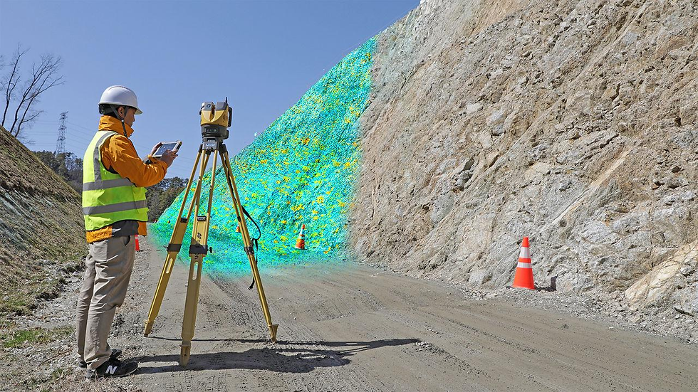
Today, modern surveying technology has revolutionized the way construction projects are planned, executed, and managed. Advanced tools such as drones, Global Navigation Satellite Systems (GNSS), LiDAR, robotic total stations, Building Information Modeling (BIM), Geographic Information Systems (GIS), and Artificial Intelligence (AI) are transforming construction workflows and delivering unprecedented levels of accuracy and efficiency.
Modern surveying is no longer limited to measuring distances and elevations. It has become a highly sophisticated process that integrates digital technologies, real-time data collection, cloud computing, and automation. These innovations help engineers, architects, contractors, and project managers make informed decisions, reduce project risks, improve productivity, and control costs.
The Evolution of Construction Surveying
Construction surveying has evolved significantly over the past few decades. Earlier methods involved extensive fieldwork, manual calculations, paper drawings, and repetitive measurements. Survey teams often spent weeks gathering data for large projects.
Several challenges existed in traditional surveying:
Limited accuracy over large distances
Slow data collection processes
High labor requirements
Greater risk of human error
Difficulty updating project information
Delays in project execution
Modern surveying technology addresses these challenges by providing digital solutions capable of collecting and processing enormous amounts of data quickly and accurately.
Today, surveyors can create highly detailed three-dimensional representations of construction sites within hours instead of weeks.
Importance of Surveying in Construction
Surveying forms the backbone of every construction project because it helps determine:
Land boundaries
Site topography
Elevation levels
Utility locations
Building positions
Infrastructure alignment
Earthwork quantities
Without accurate surveying, construction projects can face:
Cost overruns
Structural misalignment
Legal disputes
Safety hazards
Rework and delays
Modern technology significantly reduces these risks while enhancing project efficiency.
Global Navigation Satellite Systems (GNSS)
One of the most significant advancements in modern surveying is the adoption of GNSS technology.
GNSS includes satellite systems such as:
GPS
GLONASS
Galileo
BeiDou
GNSS receivers communicate with satellites to determine precise positions on Earth.
Benefits of GNSS in Construction
High Accuracy
Modern GNSS equipment can achieve centimeter-level accuracy, making it suitable for:
Highway construction
Railways
Bridges
Airports
Large industrial projects
Faster Surveys
Surveyors can collect coordinates quickly without requiring extensive ground measurements.
Real-Time Positioning
Real-Time Kinematic (RTK) systems provide instant positioning data, allowing field crews to work efficiently.
Reduced Workforce Requirements
Tasks that previously required multiple surveyors can now be completed by a single operator.
Drones and Unmanned Aerial Vehicles (UAVs)
Drones have become one of the most transformative technologies in construction surveying.

Equipped with cameras, LiDAR sensors, and GPS systems, drones capture detailed aerial imagery and site data.
Applications of Drones
Topographic Surveys
Drones quickly map large areas and generate highly accurate terrain models.
Progress Monitoring
Project managers can track construction progress regularly through aerial imagery.
Earthwork Measurements
Drone-generated models help calculate:
Cut and fill volumes
Excavation quantities
Stockpile volumes
Site Inspection
Drones can inspect:
Roofs
Towers
Bridges
Hazardous locations
without exposing workers to unnecessary risks.
Advantages
Reduced survey time
Lower operational costs
Improved safety
Frequent site updates
High-resolution imagery
A survey that once took several days can now be completed within a few hours using drone technology.
LiDAR Technology
LiDAR (Light Detection and Ranging) is one of the most advanced surveying technologies used today.

LiDAR uses laser pulses to measure distances and create detailed three-dimensional point clouds of physical environments.
How LiDAR Works
The system emits thousands of laser pulses per second.
These pulses strike surfaces and return to the sensor.
The return time is used to calculate precise distances.
Millions of measurements create highly accurate digital models.
Construction Applications
Site Mapping
LiDAR captures complex terrain with exceptional accuracy.
Existing Condition Documentation
Engineers create digital records of:
Buildings
Bridges
Roads
Industrial facilities
Infrastructure Projects
LiDAR is widely used in:
Highway construction
Railway development
Utility corridors
Benefits
Extremely high accuracy
Rapid data collection
Ability to scan inaccessible areas
Detailed 3D visualization
Robotic Total Stations
Traditional total stations required two-person crews.
Modern robotic total stations have transformed this process.
These instruments automatically track targets and perform measurements with minimal human intervention.
Features
Automatic target tracking
Remote operation
Digital data recording
Wireless connectivity
Benefits
Increased Productivity
One surveyor can perform tasks previously requiring multiple personnel.
Improved Precision
Robotic systems eliminate many manual measurement errors.
Faster Layout Work
Construction staking becomes quicker and more reliable.
Real-Time Data Integration
Measurements can be transferred directly into design software.
3D Laser Scanning
3D laser scanners have become essential tools for modern construction projects.
These scanners capture millions of measurement points in a short period.
The resulting point cloud provides a highly detailed digital representation of the site.
Uses in Construction
Building Documentation
Existing structures can be accurately modeled before renovation.
Clash Detection
Potential conflicts between structural, architectural, and MEP systems can be identified before construction.
Quality Control
Completed work can be compared with design models.
Advantages
Faster data collection
Superior accuracy
Reduced rework
Better project documentation
Building Information Modeling (BIM)
One of the most significant technological developments affecting surveying is BIM.
BIM creates intelligent digital representations of physical structures.
Survey data serves as the foundation for BIM models.
Integration of Surveying and BIM
Survey information is imported directly into BIM software.
This allows engineers to:
Design accurately
Detect errors early
Improve collaboration
Benefits
Enhanced Coordination
Architects, engineers, and contractors work from a shared model.
Better Visualization
Stakeholders can visualize the project before construction begins.
Reduced Errors
Design conflicts are detected early.
Lifecycle Management
BIM data remains useful throughout the facility's life.
Geographic Information Systems (GIS)
GIS technology helps manage and analyze spatial data.
Survey information collected in the field can be integrated into GIS platforms.
Applications
Utility mapping
Infrastructure planning
Land management
Environmental analysis
Transportation projects
Benefits
Better Decision-Making
GIS combines multiple data sources for comprehensive analysis.
Improved Planning
Engineers can evaluate site constraints more effectively.
Efficient Asset Management
Infrastructure assets can be tracked and maintained efficiently.
Machine Control Systems
Modern surveying data is increasingly connected with machine control technology.
Construction equipment such as:
Bulldozers
Excavators
Graders
can receive digital design information directly.
How It Works
Survey data is uploaded into machine guidance systems.
Equipment operators receive real-time positioning information.
Benefits
Improved Accuracy
Machines follow design grades precisely.
Reduced Rework
Errors are minimized during earthmoving operations.
Higher Productivity
Operators work faster and more efficiently.
Lower Costs
Reduced material waste and labor requirements.
Artificial Intelligence in Surveying
Artificial Intelligence is becoming an important component of modern surveying.
AI algorithms analyze vast amounts of survey data quickly.
Applications
Automated Feature Recognition
AI identifies roads, buildings, utilities, and terrain features automatically.
Error Detection
Potential measurement inconsistencies can be flagged instantly.
Predictive Analytics
Survey data can support forecasting and project planning.
Benefits
Faster data processing
Improved accuracy
Better decision-making
Reduced manual work
Cloud-Based Survey Data Management
Modern construction projects generate massive amounts of survey information.
Cloud platforms allow teams to store, share, and access data from anywhere.
Advantages
Real-Time Collaboration
Project stakeholders access updated information instantly.
Improved Communication
Survey data becomes available across departments.
Enhanced Security
Cloud systems provide backup and data protection.
Faster Decision-Making
Managers can review project conditions remotely.
Mobile Surveying Technology
Mobile devices have become valuable surveying tools.
Surveyors now use:
Tablets
Smartphones
Mobile GIS applications
to collect and manage field data.
Benefits
Digital Data Collection
Eliminates paper-based workflows.
Immediate Updates
Information is synchronized instantly.
Improved Efficiency
Field and office teams remain connected.
Digital Twins and Smart Construction
Digital twin technology represents the next stage of surveying innovation.
A digital twin is a virtual replica of a physical asset.
Survey data continuously updates the model throughout construction and operation.
Applications
Infrastructure monitoring
Facility management
Performance analysis
Predictive maintenance
Benefits
Better Asset Management
Owners receive accurate operational information.
Reduced Maintenance Costs
Potential issues can be identified early.
Improved Operational Efficiency
Facilities operate more effectively.
Safety Improvements Through Modern Surveying
Safety remains a major concern in construction.
Modern surveying technology improves safety significantly.
Examples
Drone Inspections
Workers avoid dangerous heights.
Remote Measurements
Surveyors can collect data from hazardous locations.
Real-Time Monitoring
Potential site risks can be identified early.
Accurate Planning
Fewer construction errors lead to safer work environments.
Cost Savings and Financial Benefits
One of the primary reasons for adopting modern surveying technology is cost reduction.
Areas of Savings
Reduced Labor Costs
Automation reduces workforce requirements.
Faster Project Delivery
Projects finish sooner.
Lower Rework Costs
Errors are detected early.
Improved Resource Utilization
Materials and equipment are used more efficiently.
The initial investment in advanced surveying equipment often pays for itself through increased productivity and reduced project risks.
Challenges in Adopting Modern Surveying Technologies
Despite the benefits, several challenges exist.
High Initial Costs
Advanced equipment can be expensive.
Training Requirements
Personnel need specialized skills.
Data Management Complexity
Large datasets require powerful software and storage systems.
Technology Integration
Organizations must adapt existing workflows.
However, as technology becomes more accessible and affordable, these challenges continue to decrease.
The Future of Surveying in Construction
The future of surveying is closely linked to digital transformation.
Emerging trends include:
Autonomous survey drones
AI-powered data processing
Real-time digital twins
Advanced LiDAR systems
Smart sensors
Augmented Reality (AR)
Virtual Reality (VR)
Fully automated construction workflows
Future surveyors will increasingly focus on data analysis, technology integration, and digital project management rather than manual measurements.
Construction companies that embrace these innovations will gain significant competitive advantages through improved efficiency, accuracy, and project delivery.
Conclusion
Modern surveying technology has fundamentally transformed construction projects by improving accuracy, speed, efficiency, and safety. Technologies such as GNSS, drones, LiDAR, robotic total stations, 3D laser scanning, BIM, GIS, AI, and cloud computing have revolutionized how survey data is collected, processed, and utilized.
These innovations enable construction professionals to make better decisions, reduce risks, minimize errors, optimize resources, and deliver projects more efficiently than ever before. What once required weeks of manual effort can now be accomplished within hours using advanced digital tools.
As the construction industry continues to evolve toward automation and smart infrastructure, surveying will remain at the heart of project success. The integration of emerging technologies will further enhance precision, collaboration, and productivity, making modern surveying one of the most important drivers of innovation in the global construction sector.
For today's civil engineers, understanding and embracing modern surveying technologies is no longer optional, it is essential for building successful, efficient, and future-ready construction projects.


Comments