
Basics of Surveying in Civil Engineering Chain Surveying Levelling and Modern Techniques
- Anjali Regmi
- Mar 29
- 2 min read

Introduction to Surveying
Surveying is one of the fundamental branches of civil engineering that deals with measuring distances, angles, and elevations to determine the relative position of points on the earth’s surface.
It is the first step in any construction project, as accurate data is essential for planning and design.
For students and freshers, surveying connects theoretical geometry with practical fieldwork.
Importance of Surveying in Construction
Surveying provides the base data required for designing and executing projects.
It helps in determining land boundaries, site layout, and alignment of structures.
Without proper surveying, construction may lead to errors and misalignment.
Types of Surveying

Surveying can be classified into different types.
Chain surveying is the simplest method used for small areas.
Plane table surveying involves graphical representation on site.
Traverse surveying uses angles and distances for mapping.
Modern surveying uses advanced instruments like total stations and GPS.
Chain Surveying Basics
Chain surveying involves measuring distances using chains or tapes.
It is suitable for small and simple areas.
Engineers must ensure accuracy by proper alignment and measurement techniques.
Levelling and Elevation Measurement
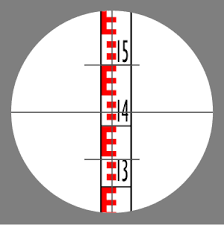
Levelling is used to determine the elevation of points.
It helps in designing drainage systems, roads, and building foundations.
Instruments such as dumpy levels and auto levels are used.
Accurate levelling ensures proper slope and alignment.
Modern Surveying Techniques

Modern surveying uses advanced technologies such as total stations, GPS, drones, and laser scanning.
These techniques provide high accuracy and faster data collection.
Engineers must learn these tools to stay updated with industry practices.
Surveying Instruments and Their Uses
Surveying instruments include chains, tapes, theodolites, levels, and total stations.
Each instrument has a specific function such as measuring distance, angle, or elevation.
Proper handling and calibration of instruments are essential for accuracy.
Field Procedures in Surveying
Surveying involves fieldwork such as marking points, taking measurements, and recording data.
Engineers must follow systematic procedures to ensure reliable results.
Proper documentation is also important.
Errors in Surveying and Their Control
Errors may occur due to instrument faults, human mistakes, or environmental factors.
Engineers must identify and minimize these errors through proper techniques and corrections.
Accuracy is critical in surveying.
Application of Surveying in Civil Engineering
Surveying is used in various fields such as road construction, building layout, and land development.
It provides essential data for planning and execution of projects.
Integration of Theory and Field Practice
Surveying combines theoretical concepts of geometry with practical fieldwork.
Engineers must apply calculations and techniques accurately on site.
Skills Required for Surveying
Engineers need precision, patience, and attention to detail.
Knowledge of instruments and data recording is essential.
Physical fitness is also important for fieldwork.
Conclusion
Surveying is the foundation of civil engineering projects.
For students and freshers, understanding surveying methods and instruments is essential for accurate project execution.
By combining theoretical knowledge with practical skills, engineers can ensure precise measurements and successful construction.


Comments